Home


Shinnecock Bay - June 1938


September 1938

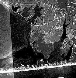
These images feature the South shore of Long Island, New York, from Democrat Point at Fire Island Inlet to just east of Shinnecock Bay.

Photograph dates: September 24, 1938. Time approx 4:15 P.M.

Aerial flight service: Believed to be U. S. Army Air Corps, 97th Obs. Sq. (C&A) AC., Mitchel Field, NY (based on labels on back of similar 1939 images).

Source of original files:
a.
Photographic archives of the Beach Erosion Board (predecessor of the Coastal Engineering Research Center), presently stored at the Coastal and Hydraulics Laboratory in Vicksburg, Mississippi, USA. Frames 001 - 012 and occasional other frames are from the BEB set.
b. Prints donated to the Coastal and Hydraulics Laboratory by Dr. Robert Dean, University of Florida. The Dean prints were better quality than the BEB ones, but some frames near inlets were missing.

Mosaic: A similar set of sepia-stained and faded images was prepared as a long, fold-open mosaic. The mosaic states: B.E.B. Accession No. 78, "Effects of the 1938 Hurricane, Fire Island, N.Y." Image 380924-000-Title is a full-color example of the color and condition of the mosaic. We do not know who at the BEB conducted studies of the hurricane effects.

Numbering convention: Digital images are labeled from east to west, beginning at Napeague Harbor (001) and ending at Democrat Point (155-FIinlet).

Altitude, lens, film type: Unknown

Historical note: These photographs were taken three days after the Great New England Hurricane of September 21, 1938. Moriches Inlet consists of several openings through Westhampton Beach, and Shinnecock Inlet occupies approximately the same location that it currently does.

Scanner: UMAX PowerLook 2100XL


Resolution: 400 x 400 dpi

Color Depth: 256 grey scale. If scanned in full color, some more data might have been extracted from some frames, but the file size would have at least tripled.

Emphasis: Scanned to emphasize features on the beach. Some images have been enhanced to improve contrast using Paint Shop Pro 7.00 software. Photo enhancements by Andrew Morang. Many of the images appear dark, with little detail in the water, but the purpose was to emphasize the beaches for use by researchers trying to map morphological features or shorelines.

Scanning Date: April 2002.


Main Photo Page


View The Images

Sept. 1938 Post-hurricane Images - Fire Island
(screen viewable - fast loading)


Sept. 1938 Post-hurricane Images - Fire Island
(printable - slow loading)


Sept. 1938 Post-hurricane Images - Ponds Zone
(screen viewable - fast loading)


Sept. 1938 Post-hurricane Images - Ponds Zone
(printable - slow loading)


Sept. 1938 Post-hurricane Images - Westhampton (Shinnecock to Moriches)
(screen viewable - fast loading)


Sept. 1938 Post-hurricane Images - Westhampton (Shinnecock to Moriches)
(printable - slow loading)