|
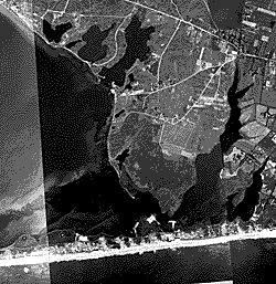
Shinnecock Bay - June
1938
|
June 1938
These images feature
the South shore of Long Island from Montauk Point to just west of Moriches
Inlet.
Photograph dates:
June 30, 1938 for Great South Beach to Ponds region and July 6, 1938 for
Montauk region.
Aerial flight
service: Believed to be U. S. Army Air Corps, Mitchel Field, NY (based
on labels on other Long Island photographs from the same era).
Mosaic: Photographs mosaiced at an unknown date. No documentation
is available stating if a study was published using these images. Mosaiced
images are shown with part of the cardboard backing.
Numbering convention: Digital images are labeled from east to west,
beginning at Great South Beach and ending at Montauk point. Images labeled
with "a" or "b" are single prints that were not used
in the mosaic.
Historical note: These photographs were taken before the Great
New England Hurricane of September 24, 1938. Shinnecock Inlet was not
open at this time, but the present location of Shinnecock Inlet is marked
by a narrow man-made channel extending part way across the barrier from
Shinnecock Bay. The channel was dug in the early 1900's in an attempt
to open a permanent inlet to improve circulation in the bay. However,
the artificial channel closed quickly due to the large littoral drift
along the ocean coast.
Scanner: Umax
Resolution: 400 x 400 dpi
Emphasis: Scanned to emphasize features on the beach. Note that
although the original photographs are in good condition, there is very
litle texture and tonality on the beaches. The sand areas are almost completely
white.
Scanning date: March 2002.
|