|
|
|
|
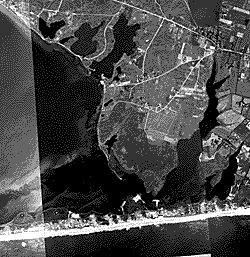
These images feature the South shore of Long Island from Montauk Point to just west of Moriches Inlet. Image source: Beach Erosion Board archives kept at the Coastal and Hydraulics Laboratory, Engineer Research and Development Center, Vicksburg, Mississippi, USA. Date: Unknown. 1941 is written on a few of the frames. The number of boats in some channels suggests that these images may have been taken on a summer weekend. Photograph agency: Unknown Film type: Unknown emulsion. The BEB paper prints were printed from 12.5 x 16 inch glass negatives. Quality: Many of the 16.25 x 20 inch prints are magnificent quality, with remarkable ground detail considering the elevation of the flight. Scanning at 600x600 dots per inch (dpi) preserved the essential data. At higher resolution, file size became unmanageable, and the extra data that was recorded consisted largely of the grain structure of the film. Most of the paper prints are well-preserved, with no discoloration or staining. Scanning Procedure:
Note: Some images appear dark when viewed on the computer screen, but the original prints were scanned to emphasize beach features for the purpose of shoreline mapping. We have tried to retain textures on the beaches. Unfortunately, some of the prints, particularly the zone east of Fire Island Inlet, have no detail on the beaches; they are completely white. Contrast adjustments: Total tonal range based on the histogram of pixel intensity. Typically, the low, mid, and high values buttons were set automatically. Then the mid-tone was moved right along the histogram to slightly lighten the overall image. Sometimes, the high value (white) button was manually moved to the end of the tail of the histogram. The midtone value then moved automatically (linearly). Cropping:
Each image cropped to include complete beach or complete barrier if applicable,
but minimize water and land. Scanned by: Doyle Jones, Amy Katzenmeyer, and Andrew Morang Scanning date: 1-7 October, 2002 Image numbers: The images are numbered sequentially from west (Fire Island Inlet) to east (Montauk Point). The "L" numbers are the numbers printed on each frame. Most flight lines ran north to south across Long Island, but flights 20, 23, and 24 ran parallel to the south shore. Some images are missing. Coverage is for Suffolk County only. We do not know there were any 1941 flights over Nassau, Queens, or Kings Counties. If any viewers have additional information about these images, please contact: Andrew Morang, Ph.D.
|
|
1941
South Shore Images
|