
BREAKOUT SESSION OBJECTIVE:
The objective of the breakout session was to discuss and expand, if necessary, the proposed problem statements and identify alternatives, opportunities, and issues of consideration for the planning and design of the potential demonstration project. Here are the results that the participants came up with. If you would like to add anything to these topics, please feel free to contact us.
PROPOSED DEMONSTRATION PROJECT LOCATION:
Kaupo Beach is located south of the Makai Research Pier. The length of the potential demonstration project area is approximately 1,500 feet. Kaiona Beach is located north of the pier, and the problem area is also approximately 1,500 feet in length. These two narrow beaches front Kalaniana'ole Highway and provide only minimal protection against wave induced impacts to the road and adjacent upland development. To the south of Kaupo Beach, a rocky headland extents out into Waimanalo Bay and provides coastal storm damage protection to the highway. North of Kaiona Beach, the highway turns mauka of the shoreline and out of harms way. Between the two problem areas, the shoreline is sheltered for wave energy by Rabbit Island and a wide shallow reef system.
PROBLEM STATEMENT: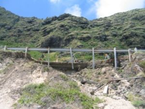
- Erosion is threatening Kalaniana'ole Highway
- Approximately 500 - 800 linear feet
- Beaches are narrow and unstable
- Erosion is undermining the highway
- What are the effects of the pier and the breakwater?
- What is the effect of the entrance channel (i.e. near shore bathymetry of area)?
- What are the effects of the beach rock shelf?
OPPORTUNITIES:
- HDOT work - report completed by E. Noda & Associates
- Good background information (need to acquire this report)
- Plan was to widen the road
- Detailed wave models can be used to determine changes in wave patterns with different structural solution "what-ifs"
- Possibility of developing site-specific sediment budget
- Impact from rock fall?
- DOH designated area for priority pollution control
ISSUES:
- High recreation use
- Increasing traffic volume (sole access around southeast O'ahu)
- Usage: fishing, surfing, windsurfing, beach goers, etc
- Freshwater seepage
- Drainage under highway
- Is it exacerbating shoreline erosion?
- Hawaiian Homelands on the mauka side of the highway
ALTERNATIVES:
- Groin in the area to trap sediment
- What would be the effects on the surrounding areas?
- Groin and beach fill
- What would be the effects on the surrounding areas?
- Bank protection at the toe
- Abandon road and implement a ferry system
- Elevate the road on piling over the beach and water
- Allow erosion to continue and to find an equilibrium on its own
- Move the road inland and create another tunnel
- Minor relocation of the road inland
- Offshore breakwater
- What would be the effects on the surf?