|
|
|
View The Images 1920
New Jersey Shore - Small Format 1920
New Jersey Shore - Large Format Additional Information Images Metadata (updated) Frequently Asked Questions (updated) USC&GS Annual Report for FY1920 (new)
A History of Flying and Photography |
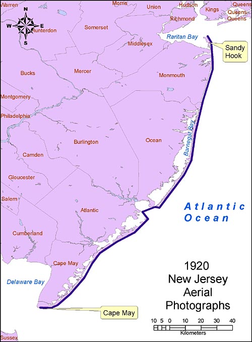
Location: Atlantic shore of New Jersey from Cape May to Sea Bright and Sandy Hook.
Approx geographic coverage: Photograph date:
Feb-March 1920. Aerial flight service: Unknown, but believed to be pioneering aerial coverage by the Fairchild Aerial Camera Company. Source of original images: Photographic archives of the Beach Erosion Board (predecessor of the former Coastal Engineering Research Center), presently stored at the Coastal and Hydraulics Laboratory, Engineer Research and Development Center, in Vicksburg, Mississippi, USA. Original image condition: Variable. These prints look like they were made quickly because many of the negatives are crooked on the photographic paper. Most are low contrast and show fading and discoloration. Printed on single-weight glossy paper. Printing date unknown. Numbering convention: Digital files are numbered the same as the original print, with numbers increasing from from south to north. Altitude, lens, time, film type: Unknown Scale: 1:10,000 (as written on envelope) Disposition of original negatives: Unknown Alternates sets of prints: None known SCANNING INFORMATION: Scanner: UMAX PowerLook 1000 FOR MORE INFORMATION: Andrew Morang, Ph.D. Tel voice: 601-634-2064 Email: andrew.morang@usace.army.mil
|